EarthWorX Viewer Properties
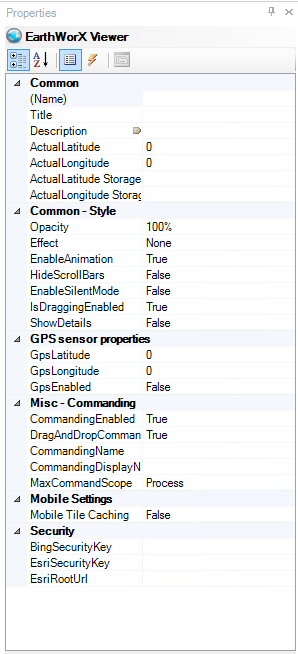
An EarthWorX Viewer object on a GraphWorX64 display has its own properties. To see the object's properties, select the EarthWorX Viewer in the Project Explorer; its properties display on the Properties tab.
EarthWorX Viewer Properties that are available in Advanced mode are described below. Note: This is a list of the more common properties. Which properties appear depend on the type of element selected within the configured display.
EarthWorX Viewer Properties
Common
-
Name - A name that describes the map's use or purpose.
-
Title - Title for the object. Unlike the Name property, the Title does not have to be unique.
-
Description - The map's description; click the ellipsis button [...] to select data from the Data Browser. You can add this to tool tips using the property below.
-
DescriptionInToolTip - Select True to include the Description property in all tool tips defined on the map. Values are Default, True, False.
-
CustomData - A free-form field that you can use as you desire, this property is typically used for holding data strings related to the EarthWorX Viewer; these data strings are typically by with custom scripts that run as part of the display.
-
ShareKeyword - A free-form field for storing keywords that are used by custom scripts that run as part of the display. This property typically holds a keyword or keywords that identify something specific about the EarthWorX Viewer that a custom script might need to find when scanning objects in the display.
-
Locked - True (the default) makes objects in the display "stick" to the map. False moves the map independently of other objects in the display.
-
Visable - Visibility state of the selected object. True will cause the element to appear on-screen while in configuration mode and False will cause it to not appear.
Common - Style
-
Opacity - The percentage of opacity for the EarthWorX map. You can select 0, 25, 50, 75, or 100, or type a number from 0 to 100. 0 makes the map completely transparent or invisible; 100 makes the map appear solid. Decreasing the map's opacity highlights objects that are on it.
-
ClipToBounds - True to clip the content of this object to bounds of this object.
-
Effect - Visual effects (3D-edge, shadow, glow, blur) applied to the object.
-
Foreground -Foreground color, gradient, or pattern of this object.
-
Background - Background color, gradient, or pattern of this object.
-
BorderBrush -
-
BorderThickness -
-
EnableAnimation - True provides a smooth animated transition from one zoom level to the next. False simply shows the new zoom level with no animated transition.
-
HideScrollBars - True hides the scrollbars in Configuration mode and Runtime mode; False displays them. This property can also be set by using the Hide Scrollbars button on the EarthWorX Configuration ribbon.
GPS Sensor Properties
-
GpsLatitude - Set the GPS sensor latitude.
-
GpsLongitude - Set the GPS sensor longitude.
-
GpsEnabled - Determine if the GPS sensor should be enabled on mobile devices where it is available.
Misc - Commanding
-
-
CommandingEnabled - Sending commands, UI, configuration enabled.
-
DragandDropCommandingEnabled - Support for drag and drop commanding.
-
CommandingName - Name used for registering the control for commanding.
-
CommandingDisplayName - Name used for registering the control for commanding.
-
MaxCommandScope - Indicates whether commands sent and received by this display affect the current process only (Process) or all processes that are currently opened (Machine) For inter-process commanding, use the Machine option.
-
Common - Behavior
-
IsEnabled - Indicates whether the selected element is enabled or not within the user interface itself.
-
IsHitTestVisible - This property is used when scripting needs to receive mouse input from the EarthWorX map. If True, allows the EarthWorX Viewer to receive focus and reports mouse-click events from runtime users, such as MouseLeftButtonDown. If the value is False, no mouse-click events are reported.
-
Cursor - The cursor that is displayed when the mouse pointer is over this object.
-
IsTabStop - Indicates whether the user can use the TAB key to give focus to this object.
-
TabIndex - Determines the index in the TAB order that this object will occupy.
-
GroupName - Gets or sets mutually exclusive RadioButton groups.
-
IsChecked - Gets or sets whether the button is checked.
-
IsThreeState - Determines whether the control supports two or three states.
|
|
Tip: When the scroll bars are hidden, there are other features that move the viewable area of the map. To pan in configuration mode, hold down the Alt key, then hold down the middle mouse button (or the wheel) and drag the mouse in any direction to move the map up, down, or sideways. In runtime, users just hold down the left mouse button to drag the map. |
-
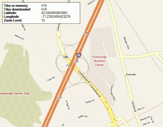
ShowDetails - True displays detailed information about the current view of the map, including the number of tiles in memory, the number of tiles that have been downloaded, the current latitude and longitude at the center of the display, and the current zoom level. False hides the information. This property can also be set by using the Show/Hide Details button on the EarthWorX Configuration ribbon.
Show/Hide Details Information
-
Shading - Determines the appearance of the map if it is a road-type map. None shows a flat, drawn map of roads; Hill shows a drawn map of roads, and elevations are indicated using shadowing. This property can also be set from the EarthWorX64 Configuration ribbon by clicking Map Type, then Road, and either No Shade or Hill Shade.
-
Type - Determines the appearance of the EarthWorX64 map. Road shows a road map; Aerial shows a satellite view; and Hybrid shows a satellite view with road map labels. This property can also be set from the EarthWorX64 Configuration ribbon by clicking the Map Type button.
Content
-
Text -Specifies the text content.
Measurements
-
Angle - The current angle of rotation for the object.
-
Left - Horizontal position of top-left corner of the object.
-
Top - Vertical position of top-left corner of the object.
-
Width - Width of the object.
-
Height - Height of the object.
-
MinWidth - Specifies the minimum width constraint of the object.
-
MinHeight - Specifies the minimum height constraint of the object.
-
MaxWidth - Specifies the maximum width constraint of the object.
-
MaxHeight - Specifies the maximum height constraint of the object.
-
HorizontalAlignment - Indicates where an element should be displayed on the horizontal axis relative to its parent element.
-
VerticalAlignment - Indicates where an element should be displayed on the vertical axis relative to its parent element.
-
Margin - The amount of space surrounding the object.
-
Padding - The amount of space surrounding the content of the object.
-
HorizontalContentAlignment - Indicates where an element should be displayed on the horizontal axis relative to the containing box.
-
VerticalContentAlignment - Indicates where an element should be displayed on the vertical axis relative to the containing box.
-
Stretch - Defines how the text of this object will be stretched when the object is resized in configuration mode.
-
RuntimeStretch - Defines how the text of this object will be stretched when the object's text changes during runtime mode.
Measurements - GPS
-
Latitude -The latitude of the center point of the object.
-
Longitude - The longitude of the center point of the object.
-
Name - The name of the EarthWorX64 (ie: The name of the object in GraphWorX64).
-
ZoomLevel - The zoom level to use.
Text
-
FontFamily - Specifies the name of the font to render text.
-
FontSize - Specifies the size of the font used to render text.
-
FontStyle - Specifies the style of the font used to render text (e.g. italic).
-
FontWeight - Specifies the thickness of the font used to render text (e.g. bold).
-
FontStretch - Specifies the degree to which a font is condense or expanded on the screen.
-
TextDecorations - Specifies the visual ornamentations added to text (underline, strikethrough).
-
TextAlignment - Specifies the horizontal alignment of the text.
-
Text Wrapping - Specifies whether or not text wraps when it reaches the edge of its containing box.
-
Text Trimming - Specifies the trimming behavior to employ if the content overflows its containing box (only used when wrapping is off).
-
IsHyphenationEnabled - Specifies whether or not hyphenation is enabled.
Visual Quality
-
SnapsToDevicePixels - Determines whether rendering for this object should use device-specific pixel settings during rendering.
-
EdgeMode - Determines the way the edges of objects are rendered.
Mobile Settings
-
SnapsToDevicePixels - Determines whether rendering for this object should use device-specific pixel settings during rendering.
Security
-
BingSecurityKey - Specifies the name of the FrameWorX Security record that contains the Bing maps key used for connection to the Bing maps.
-
EsriSecurityKey - Specifies the name of the FrameWorX Security record that contains the username and password used to connect to a secured ArcGIS server.
-
EsriRootUrl - The address of a custom ArcGIS server that provides the Esri maps.